Black Knolls
The Black Knolls trail is a lightly used equestrian trail that starts at a stepover on the Cottonwood Road about a mile and a half north of the large City of St. George water tank. There is no parking provided at the stepover. The trail follows a powerline maintenance road and ends abruptly at the top of the bluff above the Middleton Powerline trail. No link has been constructed to connect to the trail below as is shown on the original Reserve map. It is unknown whether the connection will ever be made. The southern half of the trail is frequently overgrown to the extent it is not always distinguishable to the naked eye. Approximately 2 miles long, the trail has a net elevation change of 200 feet with a total up and down change of 320 feet. The trail runs mostly across public lands managed by BLM within the Red Cliffs NCA. A modest tract of land near the trail’s center is managed by the Utah Division of Wildlife Resources and has been used as a vegetation rehabilitation site.
-
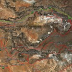
- The Black Knolls area map shows the Black Knolls trail in association with its relationship to other trails in the system.
-

- Black Knolls trail map
-
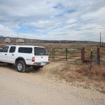
- The Black Knolls trail starts at this stepover on the Cottonwood Road with pullover parking for one vehicle.
-
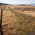
- Past the stepover, the trail heads due east following an old jeep road and is frequently covered with vegetation.
-
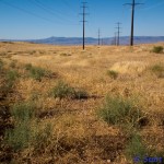
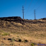
- The trail then heads south underneath the transmission line on the powerline maintenance road.
-
- The trail ends at the top of the lava bluff and does not continue south to reach the Middleton Powerline trail as of this time.