Cottontail
Formerly known as part of the Green Springs trail, the Cottontail trail is a short, 2-track, 0.6 mile connector trail to the Middleton Powerline trail with an elevation gain of about 135 feet. This easy trail offers a slightly shorter route (0.5 mile) to the Ice House trail than from the Mill Creek trailhead. As of June 2011, the trail may be accessed from the entrance to a gated community on Georgetown Drive via Green Springs Drive and Concord Parkway. About 200 yards east of the gates, an old 0.3 mile dirt road goes north to the Green Springs trailhead. As additional development occurs in this area on private land, access to the stepover on the boundary fence will change. The trail lies across lands administered by the Utah School and Institutional Trust Lands Administration.
-
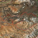
- Area map shows the Cottontail trail in relation to numerous connecting trails throughout the Middleton and Mill Creek areas.
-
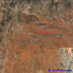
- The Cottontail trail originates from the Green Springs trailhead and serves as a connector to the Middleton Powerline trail. Access to the trailhead may vary depending upon closures on privately owned property.
-
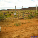
- The trail begins at its south end at this stepover on the boundary of the Red Cliffs Desert Reserve. Access is limited to unmaintained, dirt jeep roads.
-
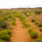
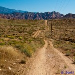
- The trail is primarily a relative level two-track jeep road through desert scrub land.
-
- The trail ends at its north intersection with the Middleton Powerline trail shown here. The Powerline trail runs from the Cottonwood Road on the west to the Mill Creek road on the east and has direct connections to the Ice House and Mustang Pass trails.