Cottonwood Trailhead
Traveling on I-15, take Exit 16 to State Hwy 9 towards Hurricane. In approximately one mile, turn left (north) at the traffic signal onto Old Hwy 91 (across from Telegraph Road). Proceed roughly 2 miles past townhomes and industrial park facilities. Turn left (west) at a small, brown trailhead sign off the left side of the road between the Winkle Distribution building (Coors Light) and the Rocky Mountain Power building and wareyard on a difficult to see dirt/gravel road, using the driveways of either building for access. Proceed through two I-15 underpasses (limited height and width) and find the trailhead within 50 yards. Tumbleweeds can sometimes impede visitors’ progress. The trailhead serves the Cottonwood Canyon trail which leads directly to the Prospector, Red Reef, Heath, and Cottonwood Hills trails with other linkages to the west (including Spanish Wash, Coachwhip, Church Rocks, Bracken’s Loop, and Grapevine). The trailhead is served by one pit toilet and has parking for numerous vehicles including horse trailers. No water or trash receptacles are provided. The trailhead lies on lands administered by the BLM within the Red Cliffs NCA.
-
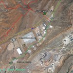
- This map shows how to gain general access to Old Hwy 91 and the trailhead from I-15 and State Route 9.
-
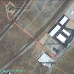
- Approximately two miles north from the junction with Hwy 9, visitors will turn left on a narrow dirt road between the Winkle Distribution facility and the Rocky Mountain Power building.
-
- To access the dirt road into the trailhead, visitors will need to proceed through the driveway of Winkle Distribution as shown here.
-

- Access may also be gained through the driveway of the Rocky Mountain Power facility as shown here.
-
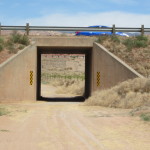
- The narrow gravel road will pass through two I-15 underpasses before reaching the trailhead.
-
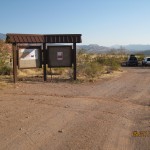
- The trailhead has ample parking for passenger vehicles and some horse trailers. One vault toilet is provided for visitor use.
-
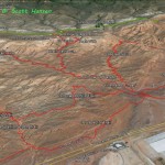
- This map shows the primary trails that are served out of the Cottonwood trailhead.